Speckled on the vast ocean, the Paracel and Spratly Islands comprise clusters of islands and islets in the South China Sea. Mostly uninhabitable and doubtfully rich with resources, the South China Sea has been the source of increasing contention officially on the legal front, but also unofficially through periodic oceanic violence among both civilian and military ships of countries surrounding the waters. Further, as the tension grew with the increased presence of military exercises and trespass into Exclusive Economic Zone (EEZ), the South China Sea has become an important battlefront in geopolitics, with China and Vietnam fighting over the Paracels, and China, Taiwan, Vietnam, the Philippines, and Malaysia fighting over the Spratlys. For these coastal nations, the battles have long existed, permutated, then revived throughout their complex history, but in recent years have taken shape as sound disputes based on legal principles.
Murky waters: Laws governing territorial claims in the South China Sea
The South China Sea lawfare is shaped by the tension between two colliding laws: the law of territorial claims based on historic rights—the foundation of China’s position and the later law set by United Nations Convention on the Law of the Sea that defines territorial rights based on geographical and physical characteristics of the state boundaries and the islands.
In the olden days, rules governing territorial claims rested on discovery principles, which were developed to settle disputes among imperialist European countries by themselves. There were five ways through which a state can acquire land: (1) conquest (by force), (2) cession (by treaty), (3) occupation (by establishing administration over terra nullius — territory called “empty land” despite the presence of natives), (4) prescription (by gradual recognition) and (5) accretion (by reclaim). The imperialistic rules soon gave way to a system of territorial claims that embrace legalistic rules and proceedings which require state parties to back their claims with demonstrable evidence such as papers, treaties and charts. These principles are what China bases its claims of historic rights on the Islands.
The claims hinge primarily on the ‘nine-dash line’ that first appeared on an official Chinese map in 1948. While “nine-dash line” has been a consistent feature in official Chinese cartography since (not without the most precise depiction and placement of the dashes themselves), its emergence into official record is less straightforward. In fact, the “nine-dash line” is the legacy of the cartographic tactic that China has employed throughout modern history to support its claims—driven by nationalist fervor, the line extending more to the south to enclose more territory each time it was claimed by another power.
Even if other states fight hard to reject the validity of China’s historic claims, China’s assertion of sovereignty on that basis may not be as “indisputable” as the state might adamantly claim due to the region’s tumultuous history in the twentieth century. In fact, when written instruments can provide evidentiary value to claims of historic rights, even Vietnam and the Philippines, and states nowhere near the islands and have no interest in the dispute—Britain and France, can declare as convincing claims as China does.
Britain, for instance, was the first state to make a modern legal claim to the Spratly Islands in 1877 for guano expedition. Even though Britain’s interest in the islands waned later on, it battled against the French for over two years over claims of sovereignty. Then, the Spratlys saw formal annexation by the French in 1933, Japanese occupation during the Second World War, and finally claims by the Philippines in 1946. By the end of WWII, fleets from the Republic of China finally were able to reach the Spratlys and removed signs of Japanese occupation from the islands, the first act of sovereignty recognizable in an international tribunal. However, not only was the act protested by the People’s Republic of China, but the Communist government also did not recognize the Republic of China, making the situation more complicated. Vietnam’s situation is also similar, as it may rest also on historic claims based on formal annexation in 1973 by the Southern Vietnamese government—power that it considered illegitimate. Vietnam’s historic claims may also be estopped by a single letter sent by the General Secretary of the Communist Party in 1958, recognizing and approving China’s declaration of its territorial sea.
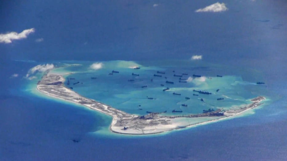
Under the United Nations Convention on the Law of the Sea (UNCLOS), to which China is a party, the governing principles rest on geography and geology. A coastal state may claim a territorial sea twelve nautical miles wide from its “low-water line along the coast,” and EEZ out to 200 nautical miles. A state’s territorial claim of islands within its bounds is governed under UNCLOS’ different category of maritime features. Only “high-tide features” may classify as islands (as opposed to “low-tide elevation”), but within that category, “rock” constitutes high-tide features that “cannot sustain human habitation or economic life of their own,” and are disqualified from generating EEZ or continental shelf (but may generate twelve nautical miles of sea) (Art. 121(3)). “Fully entitled islands” count as territory are high-tide features that are not “rocks,” meaning they must sustain human habitation or economic life (Art. 121(2)). While the Philippines and Vietnam occupy some features that meet the definition of ‘islands,’ China instead occupies ‘low-tide elevation’ features and rocks and reefs that generate no EEZs and continental territory. China may attempt to reclaim the sea by constructing artificial islands and other installations, but such effort would be unlawful appropriation under UNCLOS.
Mask and Mischief: China’s aggravation in South China Sea during COVID-19
The 2016 Permanent Court of Arbitration Tribunal ruling in the Philippines’s formal legal proceedings against China marked an international rejection of China’s claims of historic rights over the ‘nine-dash line.’ According to the Court, subject to international agreement under UNCLOS, China might not use claims of historic rights to modify nor supplement any existing rights provided under UNCLOS provisions. Unfazed by the tribunal ruling, China dismissed its obligations to adhere by UNCLOS law, and persisted in its pursuit of territorial claim within the ‘nine-dash line.’ The outbreak of COVID-19 marked rising tensions in the South China Sea as China moved more assertively on the sea in the absence of the Association of Southeast Asian Nations (ASEAN) joint efforts and US fleet patrolling the area, instigating military threats and continued invasions into other states’ EEZs and obstructions of their local economic activities. China’s actions at sea have drawn various legal responses from interested ASEAN parties, but also from the U.S., Australia, the U.K., France, and Germany. But as these notes verbales essentially reiterated the 2016 ruling, it is questionable whether the South China Sea dispute can be resolved by the existing state of international law or strikes up a Gordian knot of international lawfare, and one that might be better resolved by politics.
Author Biography: Ha Huynh is a moderator for the International Law and Policy Brief (ILPB) at The George Washington University Law School. Huynh received a B.A. in Political Science from Gustavus Adolphus College.